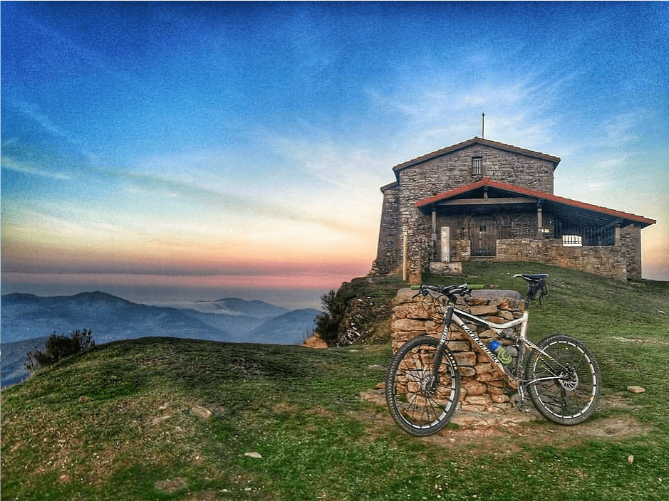
MTB Routes
Balmaseda’s mountain bike routes have three degrees of difficulty, depending on the user’s experience. All of them are circular routes, with most of them being done on tracks and paths. The blue route, the simplest of all. The red route, which beats the previous one in difficulty. And the black route, designed for the more expert.
Do you want to do a mountain bike route accompanied?
In this link you can see the activities organized by the Balmaseda Balmabike mountain bike association.
The Battle of Kolitza

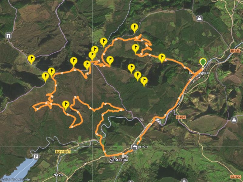
RED MTB ROUTE
- Distance: 34.7 km
- Positive altitude gain: 1,110 m
- Elevation: (min, max): 144 m, 885 m
- Difficulty: Intermediate
- Tracks: Acces via Wikiloc
Route details
We are going to visit one of the many remains that the Civil War left around Balmaseda in the form of trenches, shelters, bomb holes, etc., in the infamous Battle of Kolitza.
The route starts at San Severino Square, and through Correría Street we will go up through Pandozales to Portillo del Gato, Collado La Nevera and we will finish the route on the southern slope of Terreros (11.6 km/736 m+). After enjoying the views of the Valle de Mena and the Sierra de Ordunte, we will descend 1.1 km until the end of the wooded area hiding Cerro Cuchillo. The woodland leads to the heather plants and between them, we will have to walk 200 m to the hill.
We will go back to the road and continue towards Burgüeno, getting closer to Fuente Manzano to get some water. We will resume the path with fantastic views until the first road that descends to the left, a descent of 1 km/135 m which leads us to the forest. A few meters from a crossroads, we turn right into the beech and oak forest, taking a detour of 2.1 km to get back to the mentioned crossroads.
Then we have a steep descent of 1.8 km/317 m with considerable downhill in the final meters, but with a good road to do it safely. We will find another road, ascending on the left, adapting to the irregularities of the cliff between Burgüeno and Terreros, which we will enjoy walking between beeches, oaks and waterfalls for 3.2 km.
We will get to the road that goes down from Terreros and straight ahead we will follow another one towards Balmaseda, easy to walk through until we reach a tower of the siphon of the water pipes of the Greater Bilbao water conduction (1.7 km). We will continue crossing the barrier, a surprising 1.9 km route over the Cadagua basin, which will bring us back to the Terreros road.
We will descend to Nocedal, come out onto the road, and cross it to carry on through El Berrón to the Old Way of Santiago and then along the road to Balmaseda.
Kolitzara Mendi Martxa Route
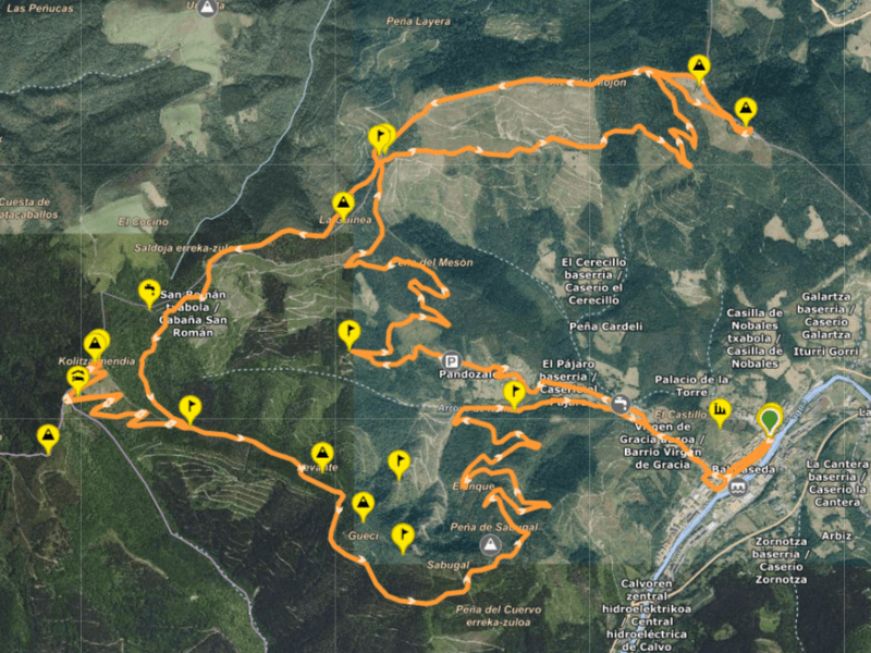
RED MTB ROUTE
- Distance: 31,58km
- Positive altitude gain: 995m
- Elevation: (min,max): 144m, 875m
- Difficulty: Half
- Tracks: Acces via Wikiloc
Route details
This route, of medium difficulty, takes us to Mount Kolitza. For Balmaseda, the banner of the town and natural viewpoint of the Cadagua Valley.
We leave from Plaza San Severino towards the Pandozales neighborhood. We continue through Casa Piedra to the track that comes from Herbosa (Sopuerta). From there, we arrive at the La Porqueriza Recreational Area and ascend to the summit of La Garbea (718 m), enjoying good views towards Balmaseda.
We descend towards the peak of Los Campazos (712 m), with views of the Salcedo Valley, Ubieta, Montes de Triano, Muskiz and the sea. We continue along the crest to La Porqueriza, then we go up the Ginea ridge to the La Potrera hill, and we continue to Portillo del Gato. We ascend to the La Nevera Recreational Area and the summit of Kolitza (874 m).
From there, we descend to the La Nevera Recreational Area, returning to Portillo del Gato and winding through the Mena Valley. We zigzag down to the Las Laceras Recreational Area and the Las Laceras Residence. Finally, we return to the town center and end up in Plaza San Severino.
Arbalitza Route

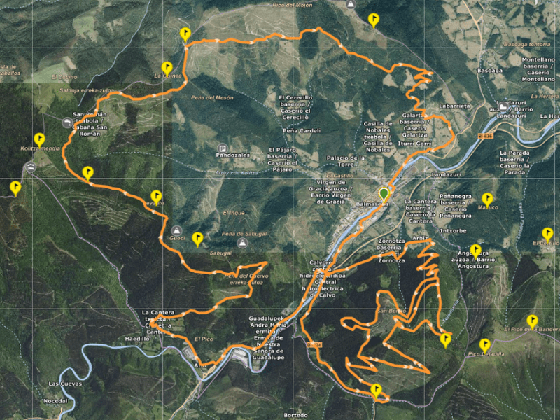
BLACK MTB ROUTE
- Distance: 39,16km
- Positive slope: 1.251m
- Elevation (min,max): 144m, 668m
- Difficulty: hard
- Tracks: Acces via Wikiloc
Route details
This route, of high difficulty, takes us to the Arbalitza summit.
To alleviate the situation we are going through, our municipality, our Villa de Balmaseda may seem small with 22.8 km2 to practice our favorite sport, MTB, but none of that goes a long way. One area is Arbalitza, where we can do 20km. If there seem to be few of them, we can expand by going up through Sabugal and down through any of those that go down to Pandozales or Castillo La Piedra, the furthest area.
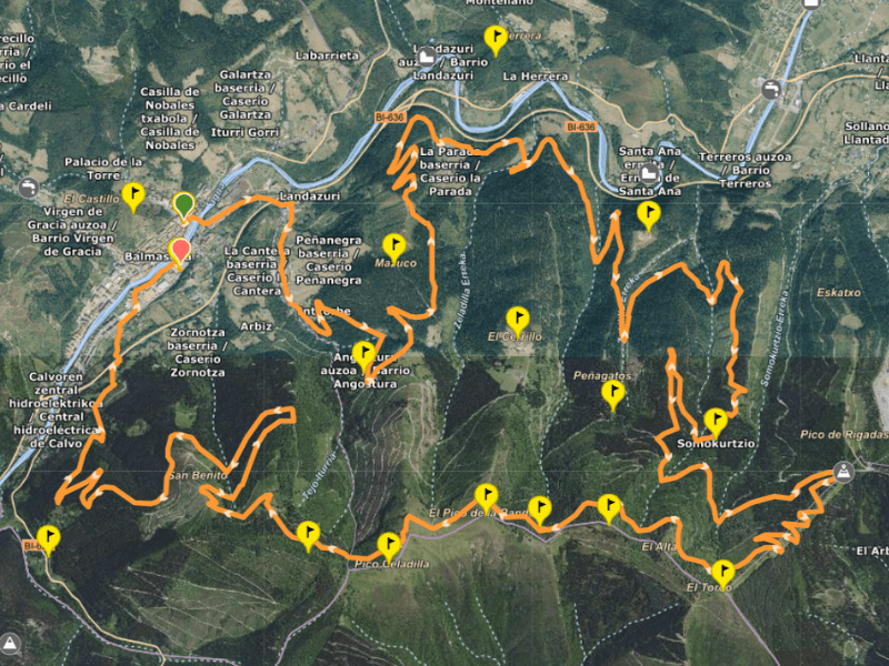
RED MTB ROUTE
- Distance: 28,77km
- Positive slope: 911m
- Elevation (min,max): 144 m, 649 m
- Difficulty: half
- Tracks: Acces via Wikiloc
Route details
This route, of medium difficulty, takes us to the Arbalitza summit.Modest summit located south of Balmaseda.
We start from Plaza San Severino and take Calle La Estación towards La Brena. We ascend through the hamlets of Angostura and border Mount Mazuco (457 m), enjoying views of Balmaseda and descending in a zigzag towards La Herrera, in Zalla. We continue towards the Bolumburu Recreational Area and climb next to El Cerco (319 m), where a fort from the II Iron Age was discovered.
We reach a hill, we descend and ascend to a track that takes us to the abandoned neighborhood of Somokurtzio. We continue to Collado Rigadas, ascending the zigzags under the Rioya (678 m) and reaching the Fuentefría spring. After a rest, we advance to Collado Trasmosomos under Espaldaseca (698 m), enjoying the views. We pass under Celadilla (697 m) along a path between cypresses and hazel trees, emerging among American oaks with views of Balmaseda.
We descend in a zigzag towards Balmaseda, taking the track that goes down to Cenarro and continue along a narrow path, crossing the pipes that bring water from Ordunte to Bilbao. We continue to the Arbiz road, we advance a few meters and go down to Calle La Calzada, next to the Renfe stop. We finish next to the sports center and arrive at the Mendiko Etxea parking lot.
Kolitza – Garbea Route
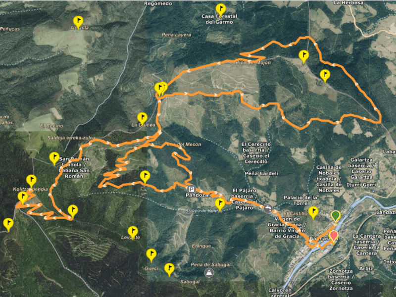
BLACK MTB ROUTE
- Distance: 32,49km
- Positive slope: 1.039m
- Elevation (min,max): 145m, 875m
- Difficulty: hard
- Tracks: Acces via Wikiloc
Route details
We leave Plaza San Severino along Correría Street towards the Pandozales road. After the Las Laceras Residence, we take the concrete track through the Pozo Gil, crossing the Arroyo del Acebo. We ascend 3.25 km along the southern slope of La Garbea, enjoying views of Kolitza and Sabugal.
We crown and descend 2.2 km to the track that goes up to La Herbosa, crossing it and ascending without difficulty 2.15 km to the summit and the Geodesic Vertex of La Garbea (718 m). We descend towards the summit of Los Campazos (712 m) and continue to the Recreational Area of La Porqueriza.
We surround the area and ascend towards the Ginea ridge (603 m), reaching the La Potrera pass, completing 4.6 km of ridge from La Garbea. From here, we have 3.8 km left to reach the summit of Kolitza. After enjoying the views, we descend to Portillo del Gato and head to the detour that goes down to Pandozales (4.7 km).
We descend along the main track towards Casa Piedra and Pandozales (4.1 km), continuing along the road to the Las Laceras Residence. Finally, we headed to the El Arroyo neighborhood and ended up at the Mendiko Etxea Parking.
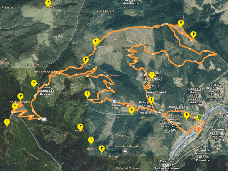
RED MTB ROUTE
- Distance: 30,89km
- Positive slope: 1.018m
- Elevation (min,max): 144m, 874m
- Difficulty: half
- Tracks: Acces via Wikiloc
Route details
We start from Plaza San Severino along Correría Street towards Pandozales and Casa Piedra (3.65 km). We continue sandwiched between the Sierra del Sabugal and the Kolitza, turning to the right after 0.4 km. We ascend in a zigzag (2.7 km) to the general Herbosa track, continuing to the right to the La Porqueriza Recreational Area (1.65 km).
We descend 0.85 km and ascend the northern slope of La Garbea (2.75 km) along a wet track between trees, passing near the neighborhoods of Herbosa, El Mazo and Otxaran. We reach the main Herbosa track, we go up and turn to the right to reach the crest and advance to La Porqueriza (2.3 km).
The last stage takes us to Kolitza, climbing generally to Portillo del Gato and zigzagging to the summit. After a rest, we descend to Portillo del Gato and towards the Pandozales track (4.8 km). We continue descending without passing through Casa Piedra, taking a sharp curve for a steep descent towards the concrete track (0.4 km).
We hit the road and head to the Mendiko Etxea, passing through the Old Bridge.
Town Of Balmaseda Route

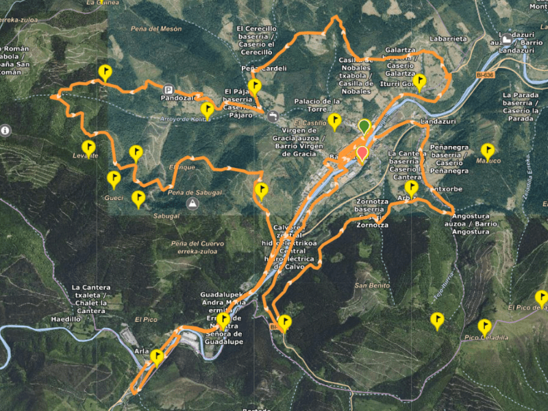
BLUE MTB ROUTE
- Distance: 29,11km
- Positive slope: 753m
- Elevation (min,max): 144m, 480m
- Difficulty: low
- Tracks: Acces via Wikiloc
Route details
We start in Plaza San Severino, walking through the old town along Calle La Cuesta, Plaza los Fueros, Calle Pío Bermejillo and returning to Plaza San Severino. We continue along Calle de la Correría, Plaza los Fueros and Avenida de las Encartaciones to the La Penilla Bridge. We cross to the El Cristo neighborhood, pass the Old Bridge and return to Plaza San Severino along Calle Martín Mendía.
We go up Paseo La Magdalena and the BI-630 highway to the La Venta del Sol neighborhood (1.3 km). We take a concrete track with views of Balmaseda, passing through Mount La Garbea (718 m) and the Trasmosomos and Santxosolo mountain range (1.4 km).
We ascend 0.4 km and then descend to Pozo Gil, exiting onto the Pandozales highway (1.85 km). We continue towards Casa Piedra and descend to Arroyo Kolitza in Peñanegra (1.9 km).
We ascend the northern slope of the Sierra del Sabugal to Peñas Blancas (472 m), descend 0.8 km and complete the Sabugal, arriving at the ruins of Bollaín. We continue along a concrete track until the BI-636 road.
We pass by the La Baluga Football Field and the El Páramo Industrial Estate (1.5 km), we cross the bridge over the Cadagua and follow the Old Camino de Santiago to the Las Oleas Bridge. We enter the Mena Valley, Burgos, and return to Balmaseda.
Finally, we cross the La Penilla Bridge, continue towards Amurrio (BI-624), cross the RENFE AM level crossing, and go up to El Cenarro (1.2 km). We descend along the Arbiz road, passing through farmhouses in the Nocedal neighborhood (2.5 km), and we end at the Lehendakari José Antonio Aguirre y Lekube Park.
Do you want to do a mountain bikeroute accompanied?
In this link you can see the activities organized by the Balmaseda Balmabike mountain bike association.